Virginia CZM Program funds Analysis of Whimbrel Migration Data
Dr. Bryan Watts and his staff at the College of William and Mary’s Center for Conservation Biology have spent decades satellite tagging whimbrels that stop on Virginia’s Eastern Shore during their annual migrations.
Using existing satellite tracks of whimbrels leaving or arriving in the critical staging sites along the DELMARVA Peninsula, Dr. Watts conducted a movement analysis of the tracks and estimated the overlap between the tracks and the Dominion and Kitty Hawk offshore wind leases. A considerable number (42.9%) of tracks intersected with one of the two wind leases. Data have been added to Movebank, a free online animal tracking database hosted by the Max Planck Institute for Ornithology at https://www.movebank.org. MoveBank helps animal tracking researchers to manage, share, protect, analyze and archive their data.
During both fall and spring migrations whimbrels followed a southeast-northwest route. However, flight altitude is likely one of the largest factors in determining the risk of collision with turbines and data on altitude is not yet available. Research on this aspect is needed as soon as possible.
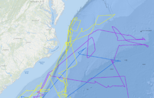
Petrel Tracks Map
Share this:


Credit: William and Mary Center for Conservation Biology