Mid-Atlantic Ocean Data Portal Winter 2023 Update
The Mid-Atlantic Ocean Data Portal recently announced several new map products, tool enhancements and informational resources for users. Skim below for links with more information on these items.
Commercial Fishing Vessel Activity: In collaboration with the Northeast Regional Ocean Council and Responsible Offshore Development Alliance, we’ve added nine maps showing vessel monitoring system data from 2015-19.
Public Agency Actions & Public Comment Opportunities: We recently created this page offering a snapshot of ocean planning activities in the region and work likely to be of interest to the Portal’s community of users.
BOEM Central Atlantic Draft Wind Energy Areas: BOEM recently concluded its public comment period on this group of wind energy areas covering approximately 1.75 million acres at sea from Delaware to North Carolina.
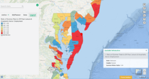
Summer Ocean Tourism Jobs: The Ratio of Summer Peak to Off Peak Leisure & Hospitality Sector Employment reveals which of the region’s coastal counties see the greatest spikes in summer employment tied to ocean tourism.
Shapes Tool: Registered users can now import GIS files from their desktops in addition to drawing and saving polygons, multi-segment lines and points with the Shapes tool.
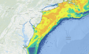
Net Primary Productivity: The Portal’s map collection showing seasonal averages for net primary productivity from Canada to Florida now covers 2010-22.
News from Our Partners: Get up to speed with relevant news from MARCO’s partner agencies.
Questions or comments on these items? Email us at portal@midatlanticocean.org.
Share this:


