Mid-Atlantic Ocean Data Portal Fall Update
The Mid-Atlantic Ocean Data Portal recently added several new map layers to its Maritime, renewable Energy, Socioeconomic and Water Quality themes. Skim below for links with more information on these products.
Wastewater Discharge & Infrastructure: Learn about the volumes, sources and sites of wastewater discharge in the ocean and its tributaries with three new map layers available on the Portal.
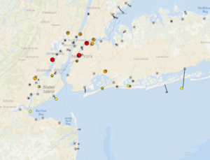
The Portal’s new Wastewater Outfalls and Discharge Flow, Wastewater Outfall Pipes, and Wastewater Facilities map layers
Marine Highways & Ro/Ros: The Maritime theme now includes a pair of maps showing the routes of Marine Highways designated by the U.S. Department of Transportation and the locations of marine roll-on/roll-off freight facilities throughout the region.
Right Whale Speed Zones: View a map of seasonal speed zones proposed by NOAA Fisheries to reduce the likelihood of injuries and mortalities among endangered North Atlantic right whales along the East Coast. Public comment on the proposal is due by Oct. 31.
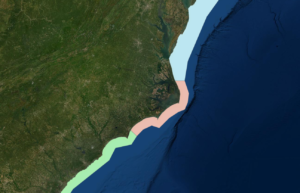
Right Whale Speed Zones
Submarine Cables: The NASCA Submarine Telecom Cables and NOAA Charted Submarine Telecom & Power Cables map layers have been retired and replaced by a new Submarine Cable Areas map provided by MarineCadastre.gov.
Late Summer Updates: We’ve also added maps showing lightering zones, the U.S. Wind offshore wind project envelope, ports by tonnage, and a final anchorage area enacted by the Coast Guard near the Cape Fear approaches.
Questions or comments on these items? Email us at portal@midatlanticocean.org.
Share this:


